

It was very good, but we didn't have enough time to absorb its message so will have a return visit.We went to a kids talent show featuring our friend's daughter Valentina, which was enjoyable and nice to be back among parents running a community event.Then a leisurely road trip up the PCH (Pacific Coast Highway), bought 20 avocados for $1, checked out the Santa Barbara museum where I hoped to find a Chumash Indian planked seagoing canoe, but didn't. Went to the Patagonia factory & didn't buy anything. Our highlight for the day was stocking up in a wholefoods supermarket in San Luis Obisbo which stocked no junk food.
 Be great if other supermarkets had similar standards. Then up to Moro Bay where we camped in the State Park & watched a beautiful sunset. The next day we watched the world championships of skateboard dual slalom in the main street, featuring ramps & jumps & lots of crashes. Then up the road to a sea elephant colony where a volunteer ranger taught us all about this species which has successfully recovered from near extinction. The males are huge & get up to 5000 lbs but the ranger said the southern sea elephant was even bigger.Then we drove along the spectacular rugged coast and moseyed into the Big Sur Jade Festival at Gorda where we went around stalls run by house truck sort of people, listened to a band and had something to eat.
 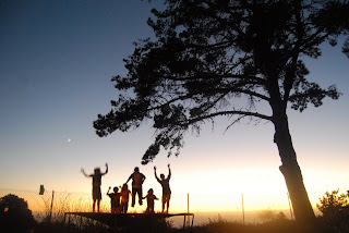 I asked a guy at the PTA cake stall if there was somewhere to camp & after chatting for awhile he invited us to camp in his yard. So we had a very enjoyable evening & the next morning with Paul & Lisa, their boys John Cruz & Corey and their sister-in-law & her boys. Its a big step for someone to open their home to 5 scruffy unkept strangers & we really enjoyed a chance to socialize with another family.Often the highlight for me on a trip overseas is being invited into someone's home and learning about their life and this was one such highlight.
Back in the van & on up the road thru stunning coastal scenery, stopping at Monterey, where we watched a colony of sea otters, also recovering from the brink of extinction, outside the famed aquarium. Fantastic to watch these remarkable creatures living in the kelp beds, floating on their backs smashing open shellfish on flat rocks they place on their bellies. The next day we headed inland across the San Jaoquin valley where the kids (and their parents) learned about the range of foods grown in this vast central valley. We stopped at a Mexican taco truck which catered for the agricultural workers & had very delicious "comida de Mexico".

That afternoon we rolled into Yosemite. We all piled into the front seat of the van to oogle at the magnificent Yosemite Valley scenery & were just parking the car when we got stopped by the cops as Lotte was on my knee and had no seatbelt. Mary sweet talked them & we were let off with a warning. We had come to Yosemite to hike to the top of Half Dome & were very disapointed to learn that the handcables up the steep rock were being dismantled the next day & that hike was closed for this season.

So we spent some time talking to the rangers to work out an alternative hike & settled on a hike out to North Dome for the following day.
We headed up the Tioga road to Porcupine Creek & headed out. Our rough plan was to all go to North Dome, Mary & the kids would walk out to Yosemite Valley & I would walk back out the way we came and shuttle the van around to pick up Mary & the kids. But about halfway out to North Dome we met Bob & Linda, a retired lawyer & his wife from Monterey who were going the other way to us, chatted for awhile and they agreed to pick up our van & do our shuttle.
So Mary handed our van keys over to total strangers which meant I could also do the whole hike.

The view from the big granite dome was stunning across to Half Dome & about 4,000 feet above the valley floor. We had a very scenic lunch and then headed out along the trail towards Yosemite falls. Much of the walk was thru big red barked cedar trees with some epic cliff views and we saw no other hikers after lunch.

We completely underestimated the distance and darkness fell as we were partway down the very steep track that descended 3,000 into the valley. The kids were great and we all needed walking sticks to probe our way down the narrow track in the darkness. The part moon helped but when the trail went thru trees it was pitch black. We did this for about three quarters of an hour, when Mary took a flash photo of me & the kids & then Max suggested we use the camera screen as a torch. Doh! So we were saved & about 30 minutes later emerged on the valley floor to find our van waiting at the trailhead. 13 miles hiked in 9 hours.

A big sleepin the next morning for everyone as we all had sore legs. Then a visit to the ranger station for junior ranger badges and seeing a coyote trying to cross a busy road was our wildlife highlight. We had lunch watching the climbing parties scaling the 4,000 foot high El Capitan wall the ascent of which takes 3 to 5 days. Very spectacular & the valley was full of rock climbers. We drove up and over the Tioga road past stunning scenery & went for a short hike up on Tioga pass in snow which had fallen the previous week. The snow gave us a taste of what the Sierras would be like in winter.

We drove down the eastern side of the mountains & even outside the national park the scenery was beautiful.
We were on a bit of a roll & put the bed down in the back of the van for the kids & Mary drove us all the way home to Grandmas via the Owens Valley in one hit arriving at the condo at 3 in the morning.

Today Max turned 14 & we had curry from the local Indian grocery store with Mary's family to celebrate. Max, Otie & their cousin Ross are at Knotts Scary Farm tonight where the amusement park is Halloonweenized for a month or so.


 Then it was off to 18 Mile road, about half an hours drive out to the distant hills. It was very windy & we didn't intend staying long but a local put us onto sheltered tracks up the hill & back down a dry creek bed which were very good and we did a couple of runs on them. The topography was not steep but the tracks were well laid out and were smooth and flowy. We started using the van as a shuttle having turn about driving. Max had driving lessons in the van to enable him to have a turn as shuttle bunny. Max & Otie headed off, with a map, on their own on a much longer trail about 6 kms long called zippidy do da, when the wind dropped, while Lotte & Mary did the shorter easier trail. At the bottom I was getting worried about the boys because big black clouds were rolling in fast & I didn't know anything about their trail. Mary arrived & dropped me back at the top & I headed off in pursuit of the boys who were about 45 minutes ahead. What a great trail, flowing thru the juniper trees, running along a knife edge ridge with very steep run offs in compacted smooth sand.
 About three quarters of the way around, the rain & wind hit me in sharp needles and about 2 minutes later the track turned to sticky clay which stopped my wheels from turning and gave me high heels as I started carrying my bike whose weight had doubled with wet clay stuck to it. The conditions were unpleasant & it took me about half an hour to make my way to the end of the track. I was relieved to see the boys back at the van who had arrived just as the rain started. But 18 Mile road is well worth a visit bike fans! Back on the road & out of Colorado & into Utah. We took a back road south & there were lots of little frogs on the road after the rain. We camped down by the Colorado putting up the tent in a lightning & rain storm and had dinner in cramped damp conditions in the van.
 We woke up to a beautiful day surrounded by red canyon walls and a peacock outside our tent. Then it was down the road beside the river flowing red from the rain past great scenery & into Moab. After a stop at a book shop we got directions from the visitors center & headed up to the Slickrock trail head & set up our camp. Then straight into it, with Mary & the boys heading out on the 16 km slickrock trail with Lotte & I tackling the 3 km practice loop. This place is something else. The Slickrock is petrified sand dunes, with the dunes 1000's of feet deep laid down hundreds of millions of years ago, then being overlain with millions of years of sediments which compacted the dunes & leached in minerals turning it to rock or Navajo sandstone. The overlying layers were eroded away during the last 10 million years as the Colorado plateau uplifted.
  So today the trail goes over this layer of smooth rock which is elevated about 200 meters above the Moab valley & part of it is on the canyon river overlooking the Colorado.


 Thousands of artifacts have been recovered from this area because when the the villages were abandoned the inhabitants could only take what they could carry & many things were left behind to be discovered a millenium later. There has been much study on the causes of the decline of this society but the accepted view is that a prolonged drought and depletion of resources (soil, wood & wildlife) caused the collapse of this small spectacular society of approximately 5000 people. We were unable to go onto the Palace house site, the biggest one with more than 200 rooms because a visit there needed a reservation and tickets which did not fit in with our spontaneous way of life. But we had an enjoyable look around the Spruce Tree house, the best preserved site, including a renovated kiva, a round below ground communal worshippy area with a sipapu, a passageway to the underworld, which luckily we couldn't fit into. We had the site and a couple of rangers almost to ourselves & they showed us how to grind corn, pointed out some ancient handprints on the wall, painting remnants on the wall plaster & the imprint of a corn cob (about 3 inches long but with big kernels) in the mud floor.


