
Our first stop in Colorado was Steamboat Springs staying and catching up with Mel & Jenny who Mary worked with on the Kern river in her rafting days back in the late 80's. After getting some locals advice we drove down to the Colorado river at Glenwood Springs where we enjoyed a couple of days kayaking on the Shoshone gorge and surfing on the local play wave. The drive down took us thru the very spectacular Glenwood canyon where the freeway winds its way in a feat of US can-do engineering down the vertical walled valley. Its probably the only place in the states where people can experiance being in a big red canyon without having to hike or raft in.
We did a couple of sessions at the Glenwood wave, part of a man made feature in the Colorado river, which has a very big flow during the spring run-off.

We saw pictures of the big wave working at the early summer flow but we had to be content with surfing the little summer remnant. We camped down by the river & were treated to a beaver swimming by one morning and a bat landed on a tree beside us in broad daylight.. We were joined for one day's kayaking by Mary's friend Jim also from her old rafting days. The whole family kayaked below the Shoshone gorge with Lotte joining us for a couple of runs down to our campsite while Jim did our shuttle.
We headed back to Steamboat for the long Labour weekend which signals the end of the summer school holidays, to spend with Mel & Jenny & their daughters Zoe & Emma. It was a
 It was a
 welcome break from camping to be based indoors, sharing meals & enjoying the c
 ompany of another family. Mel is a ninja biker & took Mary, Max & I on an epic 50 km ride along the continental divide starting at 10,000 feet at Rabbit Ears pass to Buffalo pass & then home via a locals single track called Grouse Mountain on steep switchbacks thru aspen groves & fir forest and then down a fast public walking & biking trail called Spring Bar into town.
 It was a long 6 hour ride & Max was sustained by satchets of Goo, sort of astronauts energy food which Mel had. I broke my chain on the last section & coasted downhill & chainless all the way home.

The next day Mel took me out on a ride out from town up, up, up into the hills. We went way back on a trail called upper Bear, where we saw only one other group of riders. We were out for 5 hours & I was knackered about halfway thru. Mel downloaded his GPS data after the ride to show me I had endured 27 miles with a total climb of 4000 feet. I was given Goo by some hikers we met who worked for the goo company. I understood how Max felt the day before. Meanwhile Mary & the kids went luging & goat lassooing in town. Steamboat is a compact little town with mountain bike trails & 2 skifields on the edge of town, commuter bike trails in town, playwaves on the Yampa river in town and hot springs. Sounds good eh! On our last day we took all the kids including Zoe & Emma down Spring Bar trail. Otie & I biked out to the airport
 Otie & I biked out to the airport
 to look at a small airshow and saw a Cessna ground loop (spun 180 degrees horizontally) in strong winds while landing. The planes weren't flying & there weren't many. We are so spoilt with the Wanaka airshow.


Then it was back on the road & we headed to the Rocky Mountain National Park for 3 days. Our highlights there included seeing, in the distance, a moose with massive antlers, seeing 2 coyotes sauntering across the road right by the van, driving over the high altitude road at 12000 feet and hiking there. The next day we trekked up to the top of Flattop mountain at 12100 feet. The kids are doing so well at walking up such big hills & the secret is to carry lots of water & yummy snacks & to have frequent stops.
 The kids all have their favourite snacks, Max's are sweet & salty bars, Lotte has cashew nuts & Otie loves beef jerky.
  Max felt sick at that altitude, so while he headed down with Lotte & Mary, Otie & I headed up and climbed to the top of nearby Halletts Peak which at 12700 feet was higher than the top of Mount Cook. We saw lots of pikas whose habitat was in a band of about 3000 feet and saw a flock of ptarmagins which were starting to turn white, their winter coat of feathers. This park was a little disappointing because the mountains were not craggy and many of the trees were dead from pine beetle infestation on the western side. The park felt out of balance with too many deer which eat the young trees and have destroyed the beaver habitat making them locally extinct. I reckon they need a couple of wolf packs to sort everything out. But I think we have been spoilt with the grandeur and wildlife of the other parks we had visited.
We headed out east to the cute little town of Lyon where we stayed for a couple of days with Scott Shipley, who is designing & overseeing the construction of the whitewater enhancement features on the Hawea river due to be constructed next February. Scott, his wife Hela & son Jack made us very welcome & treated us to a barbeque starring the biggest steaks we had ever seen, followed by a luxuriant soak in their hot tub. The next day Scott took time out of his busy schedule & drove me around the area looking at whitewater parks, with Max tagging along. So many towns in Colorado have revitalised their rivers flowing in & nearby, creating parks with kayak surfing waves, swimming holes, green & wooded areas. We had a close look at the Golden park which has a number of features built over the last 8 years. Scott told me many Colorado towns have zoned no development areas on their outskirts, land which has been bought by the community & local government and retained in its natural state for wildlife habitat & recreation & to limit urban sprawl. Back in Lyon, Scott has a playhole in the small river by his house & Max & I had an afternoon session on it even though the river was low.

Soon we were back on the road & drove south by Denver and onto the freeway back up into the Rockies and up into the Winter Park ski area for a mountain biking day up on the field. We bought lift passes and had a great time with Max leading the way down all the trails with Otie in hot pursuit. 
 Mary had a mellower time with Lotte & got in runs with the boys at the end of the day when their wrists were aching and just wanted to rest. Another beautiful ski area & resort which must be stunning in winter. Luckily we had no mishaps, just great riding. We drove to Frisco & stayed with Jim from the old Kern days. The next day we went to Breckenridge & caught up with Melissa, another old rafting buddy of Mary's. Breckenridge used to be a mining area with much damage caused by tailings & toxic runoff. The town has been very proactive to retain its historical atmosphere, covenanting adjoining land from development & carrying out a huge reclaimation project to re-instate the river flowing thru town with beaver, bird & fish habitat and whitewater.
  The river was previously buried under the mining tailings. Included in the reconstruction is a pool with a replica gold dredge, now a floating restaurant, near the middle of town. Melissa did a vehicle shuttle up a rail trail for us and Mary & I mountainbiked down a valley thru the forest back to her house where we stayed the night. Max was still feeling sick because of the altitude & Melissa & her husband Jerry found him a bottle of oxygen to suck on while we had dinner.
 The next day we drove thru Summit County past many 14000 foot peaks, past Vail & Copper Mountain over into the Arkansas river valley where Max & I kayaked the Numbers section which was low, bony & tight. We camped by the takeout in the company of a very sociable old hobo sleeping in his rusty car who shared our fire. We met a couple of mature local kayakers doing an after work run down the river. I suggested there should be an over 40's website enabling older kayakers to make contact with each other. They were great guys & we had a beer together. The next day we spent viewing the latest whitewater enhancements in Buena Vista & Salida. These were state of the art & what we will have on the Hawea. Unfortunately the river was low flowing at about 8 cumecs whereas the minmum flow on the Hawea will be 14. The waves at BV are beside a new village housing development being constructed by kayakers, which was very cool. Its only in the first stage but is designed so all the communal activities are in walking or biking distance, lots of green areas with climbing rocks dotted on the lawns. There is a brewery restaurant right beside the play waves.

 Mary had a mellower time with Lotte & got in runs with the boys at the end of the day when their wrists were aching and just wanted to rest. Another beautiful ski area & resort which must be stunning in winter. Luckily we had no mishaps, just great riding. We drove to Frisco & stayed with Jim from the old Kern days.
  The river was previously buried under the mining tailings. Included in the reconstruction is a pool with a replica gold dredge, now a floating restaurant, near the middle of town. Melissa did a vehicle shuttle up a rail trail for us and Mary & I mountainbiked down a valley thru the forest back to her house where we stayed the night. Max was still feeling sick because of the altitude & Melissa & her husband Jerry found him a bottle of oxygen to suck on while we had dinner.
 We moved onto Salida & was shown around by Mike Harvey who works with Scott & is responsible for the waves in this area. Max , Otie and I went for a surf on the play waves but they were not working well at the low river flow. Salida is an older town which has not been discovered & spruced up, with downtown backing right onto the river & mountain biking trails across the river which Mary & I checked out at dusk following well designed & marked trails up into the hills. It was very much like being over the Shaky bridge in Alex. It was very enjoyable & we got back after dark. Salida is a great little town.
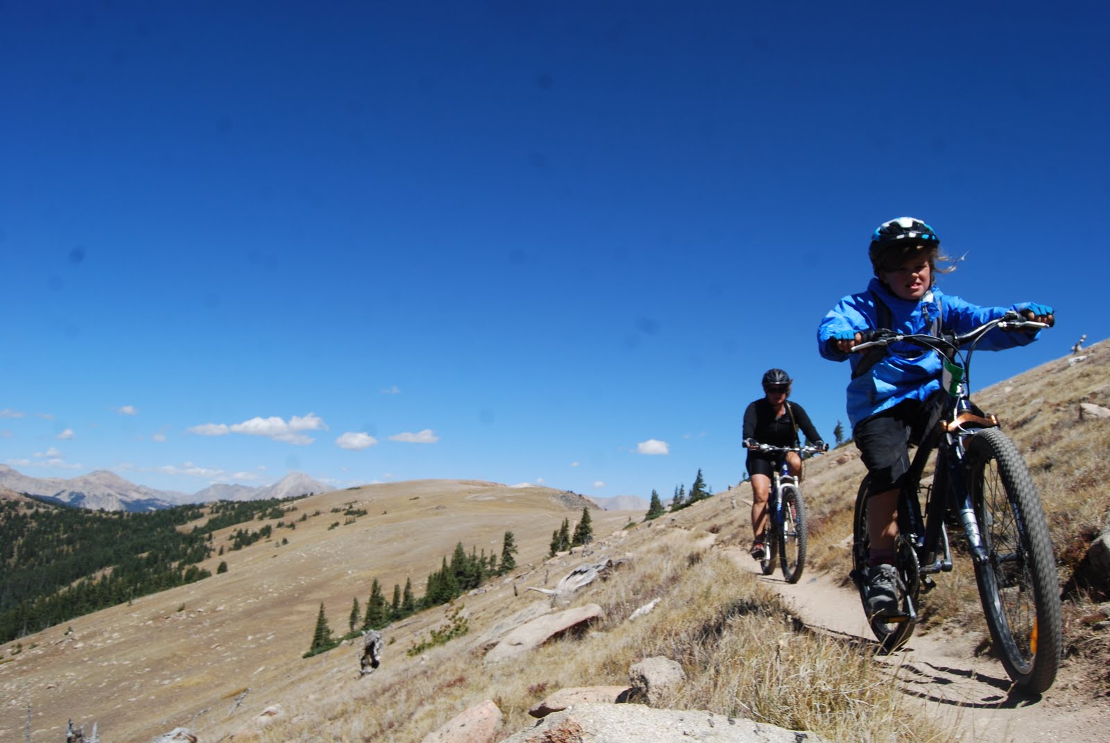
We had stopped in at the local Absolute bike shop for some maintainence earlier in the day & one of the staff told us all about the famed Monarch Crest trail which is nearby which she had taken her 8 year old nephew on so we organised for a family outing on it for the following day.
We linked up with the vehicle shuttle at the end of the trail and were drove up to Monarch pass & dropped off with a number of other bikers. We had a 900 foot climb over the first few miles up above the tree line so carefully managed Lotte up to the high point above 12000 feet and we had bought some goo along for her and the boys. We followed the continental divide trail & trans Colorado trail for about 12 miles.
The terrain wasn't hard although it was windy.  The ride was not technical & Lotte handled it with ease. The colours were pretty with the alpine tundra leaves all turning autumn colours. We met guys with horses hunting elk with bows & black powder guns. Their hunting season opens a couple of weeks before the normal hunting season. We opted to take an old rail trail back down from the tops which wound thru golden aspen groves, rather than the single track which we were told was undulating & technical. Then the last part was a long downhill on a sealed road to the van.
 The ride was not technical & Lotte handled it with ease. The colours were pretty with the alpine tundra leaves all turning autumn colours. We met guys with horses hunting elk with bows & black powder guns.
 It was a long enjoyable day with about 50kms of riding. The kids did awesome.

We loaded up our bikes & drove for about 3 hours to the Black Canyon of the Gunniston National Park where we camped the night. We often aim to camp in the parks or national monuments (sort of mini-parks) which are administered by the national parks service. There are about 350 of these in the states. The US President can declare an area a national monument but to become a national park an act of Congress is needed, I think. Many of the parks started out as national monuments. These areas are run as environmental dictatorships where the flora, fauna, rivers and landscapes are completely protected and I love being in them. We feel safe in the campgrounds and there is no commercialism. Now that the schools are back, its only us and retired folk in these campgrounds and surprisingly few overseas tourists.
 We did some walks in the park & went to a ranger talk on the geology of the canyon which is carved out of a single piece of gniess an old hard basement rock about 1.4 billion years old. We are starting to understand the the sedimentary formation and uplifting of the Colorado Plateau and its erosion over the last 10 million years. The ranger was a retired primary school teacher & a great guy who came back to park HQ & awarded Lotte & Otie their junior ranger badges after they completed a junior education program at the park. The ranger deputised me to award a night sky award once the kids completed a night sky program which I took away with me.
The kids have been doing junior ranger programs at most of the parks and monuments which have been usefull educational tools. The Gunny is a kayaking river but not frequently run & it looked steep 2000 feet below us. We saw some climbers on a big wall who just looked like specks.
Back on the road & south into the San Juan mountains stopping for the night in the very picturesque mountain town of Ouray with a fantastic chocolate & coffee shop. I went for an early morning bikeride on the perimeter trail around town as the sun came up. Oray is in a mountainous mining area with jeeps driving over the old mining trails and with the trees showing their autumn colours there were 4 wheel drive vehicles out in force.


And so we drove away from Durango & out of the Colorado Rockies after almost 3 weeks. We all loved the state & the boys are very much looking forward to return one day to ski. The locals are a physically active bunch here & there is very little obesity to be seen. There are many progressive towns with ski fields, urban whitewater play parks, organised & promoted mountain biking trails, bike commuter lanes, green protected areas on the urban fringe, farmers markets & micro breweries.


 We travelled to Missoula to check out Brennans wave, an artificial wave on the Clark Fork river flowing thru the middle of town. This was the first of a number of whitewater enhancements I plan to view in the States as part of the build up to the construction of our waves on the Hawea next year. Unlike NZ with our constant rainfall & lakes to ensure a constant flow of water in our rivers, the western US relies on snow melt to fill the rivers & once that snow is gone by mid to late summer the rivers are at a low flow.


